ORKNEY BOATPEOPLE
Getting to Orkney ca. 6,000 B.C.
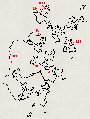 O
rkney was glaciated until around 12,000 BC. Radiocarbon dating to
around 3,500 BC has been established at four important neolithic
settlements; the Knap of Howar [
KH
on map at right] on Papa Westray associated with Unstan pottery; and
Skara Brae [
SB
] in West Mainland*, the Links of Noltland [
LN
] on Westray, and Rinyo [
R
] on Rousay, all associated with ‘Grooved’ ware. They
show Orkney to have had a resident human population living in
settlements since at least the beginning of the Neolithic period
(3,800 - 2,000 BC) in possibly two separate, coexisting cultures of
uncertain ethnicity.
“These are sites of established farming communities; it
seems unlikely that they include the homes of the first pioneering
colonists. We know effectively nothing about the first
Orcadians.”
[Berry 1985]
(To put this in some sort of context, the earliest Egyptian pyramid
at Djosser dates from ca. 2,600 BC; that at Giza and the
construction of Stonehenge date from ca 2,400 BC.)
O
rkney was glaciated until around 12,000 BC. Radiocarbon dating to
around 3,500 BC has been established at four important neolithic
settlements; the Knap of Howar [
KH
on map at right] on Papa Westray associated with Unstan pottery; and
Skara Brae [
SB
] in West Mainland*, the Links of Noltland [
LN
] on Westray, and Rinyo [
R
] on Rousay, all associated with ‘Grooved’ ware. They
show Orkney to have had a resident human population living in
settlements since at least the beginning of the Neolithic period
(3,800 - 2,000 BC) in possibly two separate, coexisting cultures of
uncertain ethnicity.
“These are sites of established farming communities; it
seems unlikely that they include the homes of the first pioneering
colonists. We know effectively nothing about the first
Orcadians.”
[Berry 1985]
(To put this in some sort of context, the earliest Egyptian pyramid
at Djosser dates from ca. 2,600 BC; that at Giza and the
construction of Stonehenge date from ca 2,400 BC.)
* Mainland
Used as a proper noun, Mainland refers to Orkney's principal island, formerly known as Hrossey or Horse Island. As a common noun it refers to the foreign country ca. 6 miles south of Orkney and not shown on the map at right.
F inds of Mesolithic-type tools from Valdigar [ V ] and Tankerness, as well as flints at Yesnaby [ Y ], the Knap of Howar again and Seatter are evidence of humans, probably seasonal migrants, earlier than the Neolithic. Mesolithic (12,000 - 3,800 BC) stone buildings are unrecorded in Orkney or Scotland, but two circular timber buildings with central hearths have been found at Wideford [ W ] on Mainland lying underneath a stone building that dates to the Early Neolithic. [Denison 2003] “A charred hazelnut shell, recovered during the excavations at Longhowe in 2007, has been dated to 6820-6660 BC. This pushed back the earliest confirmed date of the occupation of Orkney by 3,000 years” [Wikepedia: ‘Tankerness’ 2.iii.14] There was birch and hazel scrub on Orkney till around 3,500 BC. Its disappearance is ascribed partly to deteriorating climate but mainly to human activity. Evidence of humans in Orkney has been pushed back even further by flint finds on Stronsay at Links House [ LH ] in 2007. Naomi Woodward, their discoverer, said; I think that it is quite early Mesolithic, dating from between 9000 BC - 7000 BC, but we'll need to wait for dates before we can know for sure... We're hoping we can get some charcoal deposits that will allow the site to be carbon-dated. Depending on these results, we could have Orkney's first in situ evidence of Mesolithic ‘settlement’. [Internet: Orkneyjar] If the dates prove correct this will not only be the earliest evidence of humans in Orkney but in the whole of Scotland.

T here is no consensus whether any land-bridge connecting Orkney to the mainland ever existed or ig one did, when it disapperared. An animated map on a ‘Time Team’ programme [broadcast 2013] about Prehistoric tsunamis suggested that prior to the Storegga Slide (6,200 BC) such a bridge did exist. Be that as it may, two hundred years after Storegga, another massive tsunami swept across the Atlantic when the ice-wall retaining the waters of Lake Agaassiz gave way, releasing a greater volume of fresh water than all the Great Lakes put together. Apart from the direct destructive force of the water, global sea-levels would have been raised by an estimated 0.8 to 2.8 m. [Orkney is shown roughly to scale in red on the map at left; hover to see!] These tsunamis inundated ‘Doggerland’, thereby severing mainland Britain from Europe and must have swamped Orkney. J.J. Berry, citing J.D.Peacock of the British Geological Survey who wrote “it is highly unlikely Orkney was connected to the mainland after the arctic Loch Lomond Re-advance, 10,000 to 11,000 years ago” , and also Bailey in ‘Orkney’ [1971] giving as his opinion that the Pentland Firth remained dry land up to the Boreal period, about 9,500 years ago, J.J. Berry concluded; It would be wrong to be dogmatic about the existence of a land-bridge... All that it is safe to say is that any land-bridge cannot have persisted for long in conditions when animals and plants could pass over it. [Berry 1985]
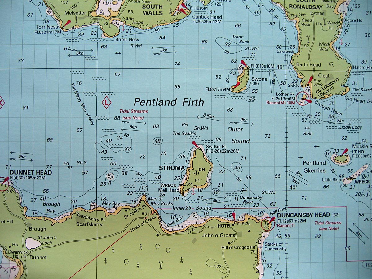
I t is estimated that sea levels may have been as much as 30 ms lower at the end of the last ice age than at present; with current charted depths of around 70 ms in the Pentland Firth between the mainland and Orkney, that still would have meant Orkney's first settlers had to cross deep water. [See navigation chart below; depths are in metres.]
T o sumarise; Orkney around 6,000 B.C, immediately post Storegga-Agassiz, must have been tabula rasa as far as humans were concerned and was probably separated from the mainland. Like most of us since, those who re-populated Orkney must have arrived by boat.
 T
he likeliest sort of boats would have been hide boats similar to
that at right; flat-bottomed, keel-less craft with hides stretched
over a timber frame, all lashed in place and waterproofed with
animal fat or resin. Construction of hide boats is quick, taking
only a few days, and such boats are still used, e.g. in the extreme
north-east of Siberia, where the indigenous people use them for
hunting walrus and collecting birds eggs from outlying islands, a
pattern of subsistence that would have been as familiar to
Mesolithic and Neolithic Orcadians as it would have been to their
18th and 19th century descendants. Dugouts were certainly used in
Neolithic Britain, but their construction requires shaping a large
mass of timber, a resource not readily obtainable in the far north
of Scotland, the presumed point of departure for early Orkney
settlers. Dugouts are also heavy to transport [e.g. if a portage is
required] and inherently unstable, especially when compared with
beamier, flat-bottomed hide boats. Unlike single dugouts, two
dugouts lashed together as a ‘catamaran’, would be
relatively stable and able to carry livestock or cargo, as would
their hide-bound counterparts. Dugouts, if used at all, and there is
no evidence in Orkney that they were, might have conferred status on
its owner or occupants, and been best used for ceremonial purposes
or for war, piracy or raiding. They would have been fast and
manoeuvrable compared to hide boats.
T
he likeliest sort of boats would have been hide boats similar to
that at right; flat-bottomed, keel-less craft with hides stretched
over a timber frame, all lashed in place and waterproofed with
animal fat or resin. Construction of hide boats is quick, taking
only a few days, and such boats are still used, e.g. in the extreme
north-east of Siberia, where the indigenous people use them for
hunting walrus and collecting birds eggs from outlying islands, a
pattern of subsistence that would have been as familiar to
Mesolithic and Neolithic Orcadians as it would have been to their
18th and 19th century descendants. Dugouts were certainly used in
Neolithic Britain, but their construction requires shaping a large
mass of timber, a resource not readily obtainable in the far north
of Scotland, the presumed point of departure for early Orkney
settlers. Dugouts are also heavy to transport [e.g. if a portage is
required] and inherently unstable, especially when compared with
beamier, flat-bottomed hide boats. Unlike single dugouts, two
dugouts lashed together as a ‘catamaran’, would be
relatively stable and able to carry livestock or cargo, as would
their hide-bound counterparts. Dugouts, if used at all, and there is
no evidence in Orkney that they were, might have conferred status on
its owner or occupants, and been best used for ceremonial purposes
or for war, piracy or raiding. They would have been fast and
manoeuvrable compared to hide boats.
 I
n Orkney the perishable organic components of hide boats would leave
little or no direct evidence of their existence in the
archaeological record, but there is plenty of evidence for their
general use in later, written historical records as well as their
being depicted in Roman mosaics and Assyrian friezes such as that
below right. Clinker building only evolved in the last centuries BC
and would have been beyond the means of early Orcadians. Even
dug-out boats would have been very labour intensive and technically
demanding given the very limited stone tools that were available,
whereas all the timber components for a hide boat might be secured
by simply cutting or breaking branches to length - see the interior
of the boat at left - and persuading a suitable animal to part with
the hull. There is ample evidence that the technology required to
work the raw materials was already to hand; bone needles and flint
and other stone cutters being comparatively common finds at
Neolithic and earlier sites in Orkney.
I
n Orkney the perishable organic components of hide boats would leave
little or no direct evidence of their existence in the
archaeological record, but there is plenty of evidence for their
general use in later, written historical records as well as their
being depicted in Roman mosaics and Assyrian friezes such as that
below right. Clinker building only evolved in the last centuries BC
and would have been beyond the means of early Orcadians. Even
dug-out boats would have been very labour intensive and technically
demanding given the very limited stone tools that were available,
whereas all the timber components for a hide boat might be secured
by simply cutting or breaking branches to length - see the interior
of the boat at left - and persuading a suitable animal to part with
the hull. There is ample evidence that the technology required to
work the raw materials was already to hand; bone needles and flint
and other stone cutters being comparatively common finds at
Neolithic and earlier sites in Orkney.
 H
ide boats are capable of carrying a significant payload of people,
livestock or other cargo. The Assyrian hide boat shown at right has
a cargo of stone. Coracles or curraghs of varying sizes, which
occured throughout the British Isles, were known to have been
capable of undertaking long journeys. St Brendan the Navigator, ca.
490-570 AD, together with fourteen monks is known to have sailed
from Ireland to Iona and beyond in a boat made of ox-hides stretched
over a wooden frame coated in lanolin. An account of his voyages,
written some 200 years later, describes sightings of land masses,
volcanoes and other features that tally with St Kilda and Iceland
and even, some claim, the fog-bound banks of Newfoundland. Such an
epic voyage was recreated by Tim Severin in 1976 who, with a small
crew, reached America in a reconstruction curragh. Such a voyage
would have been arguably easier in St Brendan's lifetime or earlier
owing to a climate that was a good deal warmer and less severe -
‘easier’ here being a relative term! There is strong
archeological evidence connecting Ireland with Orkney where
Neolithic finds suggest at least two cultures, one of which has
affinities with that prevailing in Ireland e.g. Maeshowe and
Newgrange.
H
ide boats are capable of carrying a significant payload of people,
livestock or other cargo. The Assyrian hide boat shown at right has
a cargo of stone. Coracles or curraghs of varying sizes, which
occured throughout the British Isles, were known to have been
capable of undertaking long journeys. St Brendan the Navigator, ca.
490-570 AD, together with fourteen monks is known to have sailed
from Ireland to Iona and beyond in a boat made of ox-hides stretched
over a wooden frame coated in lanolin. An account of his voyages,
written some 200 years later, describes sightings of land masses,
volcanoes and other features that tally with St Kilda and Iceland
and even, some claim, the fog-bound banks of Newfoundland. Such an
epic voyage was recreated by Tim Severin in 1976 who, with a small
crew, reached America in a reconstruction curragh. Such a voyage
would have been arguably easier in St Brendan's lifetime or earlier
owing to a climate that was a good deal warmer and less severe -
‘easier’ here being a relative term! There is strong
archeological evidence connecting Ireland with Orkney where
Neolithic finds suggest at least two cultures, one of which has
affinities with that prevailing in Ireland e.g. Maeshowe and
Newgrange.
T ravel by boat had much to recommend it to Neolithic pioneers. Hacking a way through roadless, overgrown or wooded terrain would have been difficult and time-consuming. Similarly, grass, heath or sparse vegetation must have been more appealing to settle for early colonisers than thicker vegetation or woodland, all of which required clearing with nothing more than stone tools.
We now know that the Mesolithic settlement of Scotland extended to the N coast (Wickham-Jones & Firth 2000; Pannett forthcoming). The islands of Orkney would have been visible and, to skilled sea-farers such as those of the Mesolithic, the crossing, while difficult, would not have been impossible... Once in Orkney the islands offered a rich environment to her early inhabitants. Recent palaeo-environmental work has shown the development of locally mixed woodland vegetation ... and this suggests the presence of various animals and birds. The local seas and lochs were rich and there were plenty of other resources such as fresh water and stone for tools. It is unthinkable that people did not cross the Pentland Firth to make use of the plentiful resources they would find there. [Wickham-Jones 2004]
O rkney must have been a tempting prospect then, as visibly both fertile and comparatively close, Hoy being only six miles away now and less ‘then’, [but see below for more on distances], and South Ronaldsay slightly closer, but both separated from the mainland by six miles of turbulent water, the Pentland Firth. This is the constricted bottle-neck through which the North Atlantic tries to funnel its way eastwards into the North Sea on the flood, only to be compelled by gravity some six hours later to return whence it came, spewing westwards on the ebb at a slightly diminshed rate. Early settlers may well have indulged in a bit of island hopping via Stroma and Swona in order to reduce the distance at sea to a minimum - possibly as little as three miles. But what a three miles! Nowhere in British waters are tidal streams stronger than those around Orkney. Strongest of all are those which must be encountered first by anyone journeying northwards.
Orkney has complicated tides. It is affected by two independent systems, that of the North Atlantic and that of the North Sea. The two tides reach the Orkney coast with similar strengths, but from different directions and with different timings, the Atlantic peak arriving two to three hours before the southward travelling North Sea wave. This produces a net flow of water from west to east , and complex tidal interactions among the island sounds and in Scapa Flow. Some areas such as Hoy Sound and the Pentland Firth are subject to considerable tidal streams as a result (up to nine knots in the Pentland Firth). [Berry 1985]
And yet on the same page, a little further on...
Evidence from salinity patterns and from drift bottles indicate that the net flow through the Pentland Firth is westwards . The consequence is that Orkney is roughly encircled by a clockwise set of tidal streams. [Berry 1985]
Thus reassuringly sungates - see ‘withershins’ below.
T he chart above gives only a generalized overview, with little indication of the many surprises that await the incautious or ill-prepared. Off nearly every headland in Orkney, overfalls and rough eddies develop at varying stages of the tide. For example, off the southern tip of South Ronaldsay, tide rips occur off Barth Head, The Wing, Brough Ness, Old Head and Halcro Head. A more extensive disturbance occurs between South Ronaldsay and the Pentland Skerries where the whole stretch of water on the flood develops a withershins* eddy counter to the prevailing stream. Swona, a tempting stepping stone between the mainland and Orkney, is similarly girt about by overfalls off North Head and The Tails of the Tarff to the south, and powerful eddies developing about a mile off alternating east-west. While such tidal anomalies can surprise the unwary they can be worked to advantage by someone with local knowledge. The general rule is that extensive and complex eddies develop ‘behind’ any skerry or island, to east or west of the obstruction dependant on the direction of the tidal stream. These are not small, freakish disturbances, but perturbations sufficiently severe and regular to be marked on the Admiralty tidal atlas, and big enough to swallow boats whole e.g. The Swilkie north of Stroma.
* Withershins
or widdershins , witherwardis , woderwardis : against the sun, anti-clockwise. Motion only indulged in by the foolhardy or those of evil intent. Everything in Orkney had to go sungates or clockwise.
Duncan Linklater © 2025