HOOGHLY RIVER PILOTAGE (9)
As probably experienced by Arthur David Linklater c. 1910-16
T he Bay of Bengal is a lot of water. Beyond that is the Indian Ocean - more water. During the South West Monsoon, from the middle of March till the end of October, the strong wind tries to blow this water into the 'funnel'. All year round, the tides also move water twice a day in and out of the Bay of Bengal, altering the depths 12 to 15 feet. The river disgorges large amount of water into the bay i.e. in a roughly southerly direction. Landlubbers need to be aware that a south west wind or monsoon is one blowing FROM the south west. Landlubbers also need to know that the rule of thumb is that wind against water makes for rougher conditions than wind with water. With the river in flood, an ebb tide [going out of the river] and a south west monsoon you have the ideal combination for rough or very rough water, warnings of which are printed all over the chart; "heavy breakers during bad weather" in areas of the chart showing no other immediate hazards i.e. deep water, no rocks. Add that to the funnelling effect of the bay plus deep water moving into shoal water and you have the perfect recipe for hazardous conditions. In the normal way of things a seaworthy ship can put up with rough weather, but if a ship requiring say 20 feet of water to float sails into water with a charted depth of thirty feet during rough conditions with a 20 foot swell then the ship will founder. Charted depths of water are only averages; rough weather and tidal surges caused by the same or long periods of high or low atmospheric pressure will all have an effect on the actual depth of water. The people who are expert in all such niceties are pilots. Anything causing a ship to lose steerage such as dismasting, fouled rudder, engine failure etc within the ‘funnel’ would place the ship in jeopardy or "standing into danger".
 O
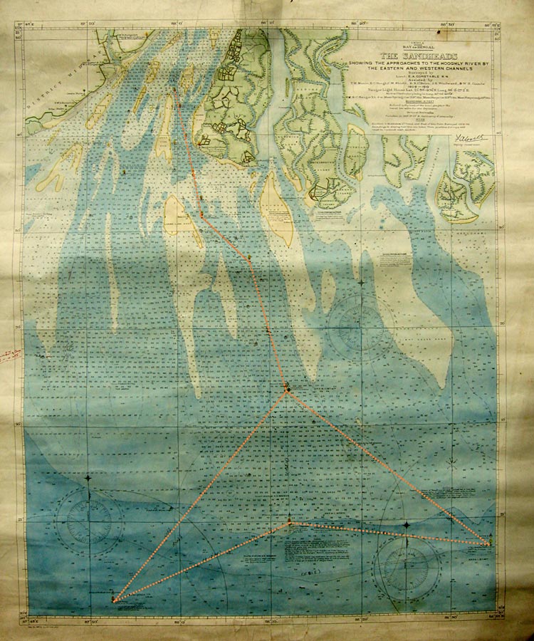
n Arthur's chart of the Sandheads the funnel shape is clearly
mimicked by the buoyage and lightships; see the image at right,
where the orange dotted outline is mine, but at each angle or kink
the chart indicates the presence of either a lightship or a buoy.
All the lightships are described as having lights 44 feet high with
a visibility of 12 miles. Arthur states that all the lighships were
manned apart from the Middleton. This is supported by the chart
which only specifically mentions manning in so far as to state that
the Middleton is "unattended" - presumably because Middleton was
only a couple of miles from the shore and adjacent to Saugor
Lighthouse. Across the mouth of the bay three lightships are shown.
The westernmost, at bottom left, is called Pilots Ridge positioned
at 20° 51.5’ N. and 87° 52.5’ E. The easternmost
is Mutlah at 20° 57’ N. and 88° 34.5’ E. These
two are about 40 miles apart and both are anchored in deep water.
Roughly midway between the two is Eastern Channel lightship at
20° 59.5’ N. and 88° 12’ E. and anchored close
to the southernmost part of the shoal water at the 60 ft. line. The
size and visibility of these three lightships is such that any
vessel approaching the Hooghly from sea should see one of them. From
the different characteristics of each of their flashing lights their
identity could be determined and thus the ship's position known and
a course set to proceed inwards, if heading for Calcutta, to the
next safe mark; that at the start of the funnel, the
‘Intermediate’ lightship, at 21° 13.5’ N. and
88° 12’ E., this being about 14 miles N. 2° W. from
Eastern Channel lightship.
O
n Arthur's chart of the Sandheads the funnel shape is clearly
mimicked by the buoyage and lightships; see the image at right,
where the orange dotted outline is mine, but at each angle or kink
the chart indicates the presence of either a lightship or a buoy.
All the lightships are described as having lights 44 feet high with
a visibility of 12 miles. Arthur states that all the lighships were
manned apart from the Middleton. This is supported by the chart
which only specifically mentions manning in so far as to state that
the Middleton is "unattended" - presumably because Middleton was
only a couple of miles from the shore and adjacent to Saugor
Lighthouse. Across the mouth of the bay three lightships are shown.
The westernmost, at bottom left, is called Pilots Ridge positioned
at 20° 51.5’ N. and 87° 52.5’ E. The easternmost
is Mutlah at 20° 57’ N. and 88° 34.5’ E. These
two are about 40 miles apart and both are anchored in deep water.
Roughly midway between the two is Eastern Channel lightship at
20° 59.5’ N. and 88° 12’ E. and anchored close
to the southernmost part of the shoal water at the 60 ft. line. The
size and visibility of these three lightships is such that any
vessel approaching the Hooghly from sea should see one of them. From
the different characteristics of each of their flashing lights their
identity could be determined and thus the ship's position known and
a course set to proceed inwards, if heading for Calcutta, to the
next safe mark; that at the start of the funnel, the
‘Intermediate’ lightship, at 21° 13.5’ N. and
88° 12’ E., this being about 14 miles N. 2° W. from
Eastern Channel lightship.
Duncan Linklater © 2025